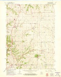
1961 Map of Kieler
USGS Topo · Published 1973About this map
The hills and coulees of southwestern Wisconsin are meticulously captured in this study of Grant County and the border of Jo Daviess County, Illinois. The landscape is defined by its religious and educational centers, most notably at Sinsinawa where the Sinsinawa Mound stands near St Joseph Sch and the St Clara Cem. These sites serve as historic anchors for the surrounding rural communities of Dickeyville, Kieler, and Jamestown.
Find a feature on this map
34 named features on this map. Tap any name to fly to it.
Don’t see what you’re looking for? This feature index may not catch every label — zoom into the map to look around manually.
Map Details
Editions of this 1961 Kieler Map
3 editions found
Other maps of this area

1900 · Lancaster
USGS Topo · 1:125,000

1901 · Peosta
USGS Topo · 1:125,000

1902 · Mineral Point
USGS Topo · 1:125,000

1904 · Lancaster
USGS Topo · 1:125,000

1908 · Lancaster
USGS Topo · 1:125,000

1911 · Galena
USGS Topo · 1:62,500

1913 · Galena
USGS Topo · 1:62,500

1935 · East Dubuque
USGS Topo · 1:62,500

1940 · East Dubuque
USGS Topo · 1:62,500

1952 · Platteville
USGS Topo · 1:24,000