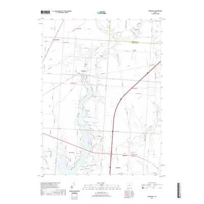
2019 Map of Kilbourne
USGS Topo · Published 2019About this map
Alum Creek and its many tributaries, including Salt Well Run and Longwell Run, dominate the landscape of central Delaware County. The settlement at Kilbourne is anchored by Green Mound Cem and Old Kilbourne Cem, providing a clear point of reference for genealogists studying the local families of Berkshire Township. The map illustrates the convergence of rural infrastructure and small-town development, showing Berkshire and the northern edge of Sunbury connected by a network of established county roads. Aviation history is noted by the presence of Erdy Farm Airport and Bohannan Airport, while natural landmarks like Bald Lick and Hunter's Hollow detail the varied topography. The boundary between Morrow Co and Delaware Co is clearly delineated in the northern reaches, near the small community of Leonardsburg.
Find a feature on this map
102 named features on this map. Tap any name to fly to it.
Don’t see what you’re looking for? This feature index may not catch every label — zoom into the map to look around manually.
Map Details
Editions of this 2019 Kilbourne Map
This is the sole edition of this map. No revisions or reprints were ever made.
Other maps of this area

1901 · Dublin
USGS Topo · 1:62,500

1902 · Westerville
USGS Topo · 1:62,500

1903 · Dublin
USGS Topo · 1:62,500

1904 · Westerville
USGS Topo · 1:62,500

1915 · Marengo
USGS Topo · 1:62,500

1924 · Delaware
USGS Topo · 1:62,500

1925 · Delaware
USGS Topo · 1:62,500

1943 · Marengo
USGS Topo · 1:62,500

1944 · Delaware
USGS Topo · 1:62,500

1950 · Marion
USGS Topo · 1:250,000