
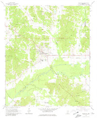
1966 Map of Kilmichael
USGS Topo · Published 1967About this map
Kilmichael serves as the central hub of this mid-1960s survey, situated along the Columbus and Greenville railroad line and a highway network that includes a local Roadside Park. The landscape is defined by the winding course of the Big Black River and the engineered Big Black River Canal, which manage drainage across the region's southern half. Numerous family-named landmarks and institutions provide a window into the rural social fabric of Montgomery County, including the Vocational High Sch and a series of rural sanctuaries like Pleasant Grove Ch and Nations Poplar Creek Ch. The presence of Sandpits and a Claypit near the main settlement suggests the importance of local material extraction during this era of development. Small communities such as Sibleyton and Hendrix are also documented, alongside several cemeteries including Flowers Cem and Griffin Cem.
Find a feature on this map
39 named features on this map. Tap any name to fly to it.
Don’t see what you’re looking for? This feature index may not catch every label — zoom into the map to look around manually.
Map Details
Editions of this 1966 Kilmichael Map
2 editions found
Other maps of this area

1953 · Walthall
USGS Topo · 1:62,500

1953 · West Point
USGS Topo · 1:250,000

1954 · Duck Hill
USGS Topo · 1:62,500

1958 · West Point
USGS Topo · 1:250,000

1963 · West Point
USGS Topo · 1:250,000

1966 · Poplar Creek
USGS Topo · 1:24,000

1966 · Winona
USGS Topo · 1:24,000

1966 · Stewart
USGS Topo · 1:24,000

1966 · French Camp
USGS Topo · 1:24,000
1966 · Vaiden
USGS Topo · 1:24,000