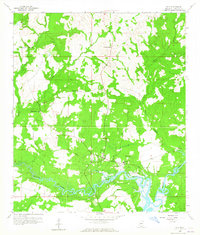
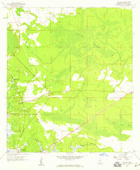
1959 Map of Kiln
USGS Topo · Published 1965About this map
The Jourdan River meanders through the southern portion of this landscape, its tidal reaches and associated bayous defining the geography of eastern Hancock County in the late 1950s. The settlement of Kiln serves as a local hub, featuring the Kiln Sch and Annunciation Ch. This area's rural character is emphasized by the distribution of country churches and small family or community burying grounds, such as Catahoula Ch and the Bayou Coco Cem. The intricate network of waterways, including Bacon Bayou, Bayou La Terre, and the appropriately named Rotten Bayou, suggests a coastal economy deeply tied to the marshes and timberlands. To the north, the terrain becomes more varied near Little Providence Ch, while the presence of a Lookout Tower indicates the importance of fire surveillance in the surrounding pine forests.
Find a feature on this map
20 named features on this map. Tap any name to fly to it.
Don’t see what you’re looking for? This feature index may not catch every label — zoom into the map to look around manually.
Map Details
Editions of this 1959 Kiln Map
4 editions found
Other maps of this area

1914 · Nicholson
USGS Topo · 1:62,500

1921 · Nicholson
USGS Topo · 1:62,500

1953 · Mobile
USGS Topo · 1:250,000

1955 · Savannah
USGS Topo · 1:62,500

1956 · Bay St. Louis
USGS Topo · 1:24,000

1956 · Vidalia
USGS Topo · 1:24,000

1956 · Waveland
USGS Topo · 1:24,000

1957 · Mobile
USGS Topo · 1:250,000

1957 · Dead Tiger Creek
USGS Topo · 1:24,000
1958 · Logtown
USGS Topo · 1:24,000