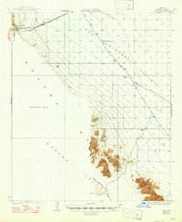
1931 Map of Kim
USGS Topo · Published 1947About this map
Kim and the Southern Pacific railroad line define the northern edge of this arid landscape, surveyed by Bishop Moorhead and C.N. Mortenson in the late 1920s. The terrain is dominated by the San Cristobal Valley and the Mohawk Valley, separated by the steep rises of the Mohawk Mountains. Water sources are scarce and vital, marked by isolated points such as Pimoria Well, Garcia Well, and White Well, which served as critical stops for travelers navigating the Yager Road and the Yuma - Gila Bend Road. The southern portion of the sheet remains an Unsurveyed Area, reflecting the difficulty of mapping this remote desert interior. A notable crossing at Mohawk Pass provides a gateway through the range, while the Mohawk - Papago Well Road skirts the southern foothills, illustrating the rudimentary transit network established before modern desert infrastructure.
Find a feature on this map
13 named features on this map. Tap any name to fly to it.
Don’t see what you’re looking for? This feature index may not catch every label — zoom into the map to look around manually.
Map Details
Editions of this 1931 Kim Map
3 editions found
Other maps of this area

1926 · Mohawk
USGS Topo · 1:62,500

1927 · Aguila Mountains
USGS Topo · 1:48,000

1927 · Kim
USGS Topo · 1:62,500

1928 · Mohawk
USGS Topo · 1:62,500

1928 · Norton
USGS Topo · 1:62,500

1929 · Aztec
USGS Topo · 1:62,500

1929 · Norton
USGS Topo · 1:62,500

1930 · Aguila Mountains
USGS Topo · 1:62,500

1930 · Stoval
USGS Topo · 1:62,500

1931 · Kim
USGS Topo · 1:62,500