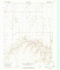
1962 Map of Kimball
USGS Topo · Published 1977About this map
The Chicago Rock Island and Pacific railroad cuts across the northwest corner of this Panhandle landscape, serving as a primary transport artery for the surrounding agricultural and energy sectors. Energy production dominates the local economy, marked by the extensive Shapley Gas and Oil Field, North Gas and Oil Field, and Hansford Gas and Oil Field. The topography is defined by the dramatic descent into the Farwell Draw and the course of Palo Duro Creek in the south, where the plains give way to more complex drainage patterns. Small settlements like Kimball and Tomlinson provide focal points for local history, while the Farwell Cem remains a significant landmark for genealogical research. The presence of numerous wells and a pipeline network illustrates the mid-century industrialization of this section of Hansford County.
Find a feature on this map
22 named features on this map. Tap any name to fly to it.
Don’t see what you’re looking for? This feature index may not catch every label — zoom into the map to look around manually.
Map Details
Editions of this 1962 Kimball Map
2 editions found
Other maps of this area

1954 · Perryton
USGS Topo · 1:250,000

1958 · Perryton
USGS Topo · 1:250,000

1962 · Kimball
USGS Topo · 1:24,000

1962 · Hansford Camp
USGS Topo · 1:24,000

1962 · Hansford
USGS Topo · 1:24,000

1962 · Waka SW
USGS Topo · 1:24,000

1962 · Spearman
USGS Topo · 1:24,000

1973 · Gruver
USGS Topo · 1:24,000

1974 · Hannas Draw East
USGS Topo · 1:24,000

1974 · Bernstein
USGS Topo · 1:24,000