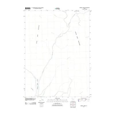
2011 Map of Kimbell Creek
USGS Topo · Published 2011About this map
The Grouse Creek Mountains dominate the eastern and northwestern horizons of this drainage basin, where high-desert watercourses define the layout of the land. In the northern reaches, Cotton Thomas Basin serves as a collection point for various seasonal flows, including Basin Creek and First Creek. A network of unpaved corridors, most notably Grouse Creek Rd and Cotton Thomas Rd, follows the natural contours of the valley floors. The convergence of numerous named streams, such as Little Pole Creek and Cotton Creek, into the broader Grouse Creek Valley illustrates a landscape where ranching and resource management are dictated by the sparse, precious hydrology of the region. Local family names or early settler identifiers are preserved in landmarks like Joe Dahar Creek and Ed Richie Creek, providing essential geographic markers for researchers of this high-basin territory.
Find a feature on this map
14 named features on this map. Tap any name to fly to it.
Don’t see what you’re looking for? This feature index may not catch every label — zoom into the map to look around manually.
Map Details
Editions of this 2011 Kimbell Creek Map
This is the sole edition of this map. No revisions or reprints were ever made.
Other maps of this area

1954 · Brigham City
USGS Topo · 1:250,000

1958 · Brigham City
USGS Topo · 1:250,000

1959 · Cotton Thomas Basin
USGS Topo · 1:62,500

1959 · Yost
USGS Topo · 1:62,500

1962 · Brigham City
USGS Topo · 1:250,000

1971 · Potters Creek
USGS Topo · 1:24,000
1971 · Grouse Creek
USGS Topo · 1:24,000
1971 · Ingham Canyon
USGS Topo · 1:24,000

1987 · Grouse Creek
USGS Topo · 1:100,000
1990 · Buck Hollow
USGS Topo · 1:24,000