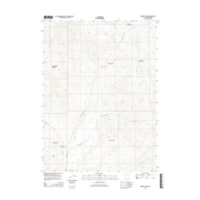
2014 Map of Kimbell Creek
USGS Topo · Published 2014About this map
Grouse Creek Valley and the surrounding high country define this section of the Utah-Nevada borderlands in northwestern Box Elder County. This 2014 survey details the topographic interface between the Goose Creek Mountains and the Grouse Creek Mountains, where a network of unpaved corridors like Cotton Thomas Rd and Goose Creek Rd provide the primary access to this ranching and grazing landscape. The drainage system is particularly well-defined, showing how Kimbell Cr and the N Fork Pine Cr collect runoff from the basins and hollows. The presence of Jack Hollow and the Cotton Thomas Basin illustrates the complex erosional patterns typical of this Great Basin environment. For researchers, the map provides a precise look at the township and range boundaries that govern these remote public and private land tracts, illustrating the enduring spatial organization of the rural West.
Find a feature on this map
22 named features on this map. Tap any name to fly to it.
Don’t see what you’re looking for? This feature index may not catch every label — zoom into the map to look around manually.
Map Details
Editions of this 2014 Kimbell Creek Map
This is the sole edition of this map. No revisions or reprints were ever made.
Other maps of this area

1954 · Brigham City
USGS Topo · 1:250,000

1958 · Brigham City
USGS Topo · 1:250,000

1959 · Cotton Thomas Basin
USGS Topo · 1:62,500

1959 · Yost
USGS Topo · 1:62,500

1962 · Brigham City
USGS Topo · 1:250,000

1971 · Potters Creek
USGS Topo · 1:24,000
1971 · Grouse Creek
USGS Topo · 1:24,000
1971 · Ingham Canyon
USGS Topo · 1:24,000

1987 · Grouse Creek
USGS Topo · 1:100,000
1990 · Buck Hollow
USGS Topo · 1:24,000