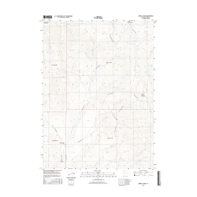
2017 Map of Kimbell Creek
USGS Topo · Published 2017About this map
Grouse Creek Valley serves as a central corridor between the high peaks of the Goose Creek Mountains to the west and the Grouse Creek Mountains to the east. This 2017 survey details a remote corner of Box Elder County where a network of unpaved tracks, such as Kimball Creek Rd and Cotton Thomas Rd, connects the basin floors to high-elevation drainages. The landscape is defined by its complex hydrology, with numerous seasonal and perennial flows including Kimbell Creek, Little Pole Cr, and Joe Dahut Cr cutting through the terrain. Significant landmarks like Cotton Thomas Basin and the depression of Jack Hollow illustrate the rugged topography and drainage patterns that have historically influenced cattle ranching and land use in this high desert environment.
Find a feature on this map
25 named features on this map. Tap any name to fly to it.
Don’t see what you’re looking for? This feature index may not catch every label — zoom into the map to look around manually.
Map Details
Editions of this 2017 Kimbell Creek Map
This is the sole edition of this map. No revisions or reprints were ever made.
Other maps of this area

1954 · Brigham City
USGS Topo · 1:250,000

1958 · Brigham City
USGS Topo · 1:250,000

1959 · Cotton Thomas Basin
USGS Topo · 1:62,500

1959 · Yost
USGS Topo · 1:62,500

1962 · Brigham City
USGS Topo · 1:250,000

1971 · Potters Creek
USGS Topo · 1:24,000
1971 · Grouse Creek
USGS Topo · 1:24,000
1971 · Ingham Canyon
USGS Topo · 1:24,000

1987 · Grouse Creek
USGS Topo · 1:100,000
1990 · Buck Hollow
USGS Topo · 1:24,000