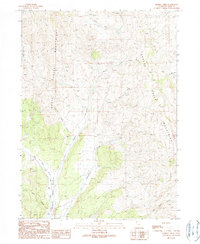
1990 Map of Kimbell Creek
USGS Topo · Published 1990About this map
The Grouse Creek Mountains dominate this high-desert landscape of northwestern Utah, where a complex network of seasonal drainages carves through the high elevations. The map reveals an area defined by its hydrology and resource extraction, with multiple quarries located in the northern reaches near First Creek. The western portion of the quadrangle is marked by the broad Grouse Creek Valley, into which several watercourses descend, including Joe Dahar Creek and Jack Hollow.
Find a feature on this map
15 named features on this map. Tap any name to fly to it.
Don’t see what you’re looking for? This feature index may not catch every label — zoom into the map to look around manually.
Map Details
Editions of this 1990 Kimbell Creek Map
This is the sole edition of this map. No revisions or reprints were ever made.
Other maps of this area

1954 · Brigham City
USGS Topo · 1:250,000

1958 · Brigham City
USGS Topo · 1:250,000

1959 · Cotton Thomas Basin
USGS Topo · 1:62,500

1959 · Yost
USGS Topo · 1:62,500

1962 · Brigham City
USGS Topo · 1:250,000

1971 · Potters Creek
USGS Topo · 1:24,000
1971 · Grouse Creek
USGS Topo · 1:24,000
1971 · Ingham Canyon
USGS Topo · 1:24,000

1987 · Grouse Creek
USGS Topo · 1:100,000
1990 · Buck Hollow
USGS Topo · 1:24,000