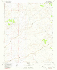
1967 Map of Kimbeto
USGS Topo · Published 1981About this map
Kimbeto serves as the focal point of this arid landscape in the high desert of the San Juan Basin during the late 1960s. The map illustrates a sparse settlement pattern dictated by water access, with the intermittent Kimbeto Wash and Betonnie Tsosie Wash cutting broad, sandy paths through the terrain. A notable genealogical and local history detail is the inclusion of the Tony Lopez Well, indicating specific family-held water resources in a region where such landmarks were vital for ranching and survival. The infrastructure of the mid-20th century is evident through a prominent Pipeline and scattered industrial markers like a Drill Hole, reflecting the area's role in resource extraction. This survey, based on 1965 aerial photography, provides a clear view of the traditional land use and early energy development before significant modernization altered the rural character of this New Mexico quadrangle.
Find a feature on this map
9 named features on this map. Tap any name to fly to it.
Don’t see what you’re looking for? This feature index may not catch every label — zoom into the map to look around manually.
Map Details
Editions of this 1967 Kimbeto Map
2 editions found
Other maps of this area

1889 · Largo
USGS Topo · 1:250,000

1895 · Largo
USGS Topo · 1:250,000

1954 · Aztec
USGS Topo · 1:250,000

1958 · Aztec
USGS Topo · 1:250,000

1959 · Nageezi
USGS Topo · 1:62,500

1962 · Aztec
USGS Topo · 1:250,000

1965 · Aztec
USGS Topo · 1:250,000
1966 · Pueblo Bonito
USGS Topo · 1:24,000
1966 · Pueblo Bonito NW
USGS Topo · 1:24,000

1966 · Lybrook NW
USGS Topo · 1:24,000