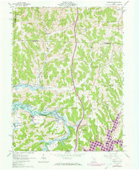
1962 Map of Kimbolton
USGS Topo · Published 1973About this map
Kimbolton sits at a geographic crossroads in Guernsey County, where the Penn Central railroad follows the valley of Wills Creek. The landscape recorded in this early 1960s survey, with later updates, shows a transition from traditional agrarian and rail-based settlement toward the modern watershed management of the Muskingum Watershed Conservancy District. Evidence of the region’s extractive history is found in the Strip Mines north of town and scattered Oil Wells. Local genealogy is well-preserved through numerous rural landmarks, including St Jacob Ch and the Earleys Cem. To the south, the emergence of Salt Fork Lake and the established Wills Creek Lake illustrate the large-scale water control projects that reshaped the terrain around North Salem and Guernsey during this era.
Find a feature on this map
43 named features on this map. Tap any name to fly to it.
Don’t see what you’re looking for? This feature index may not catch every label — zoom into the map to look around manually.
Map Details
Editions of this 1962 Kimbolton Map
Other maps of this area

1909 · Antrim
USGS Topo · 1:48,000

1909 · Uhrichsville
USGS Topo · 1:62,500

1909 · Cambridge
USGS Topo · 1:62,500

1911 · Antrim
USGS Topo · 1:62,500

1911 · Uhrichsville
USGS Topo · 1:62,500

1911 · Newcomerstown
USGS Topo · 1:62,500

1912 · Cambridge
USGS Topo · 1:62,500

1913 · Newcomerstown
USGS Topo · 1:62,500

1943 · Newcomerstown
USGS Topo · 1:62,500

1951 · Canton
USGS Topo · 1:250,000