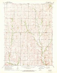
1968 Map of Kimeo
USGS Topo · Published 1969About this map
Kimeo and Chepstow anchor this rural landscape along the border of Washington and Riley Counties during the late 1960s. The topography is defined by the branching drainages of the North Fork Fancy Creek and Deadman Creek, which carve deep, undulating patterns into the Kansas prairie. These waterways dictated the placement of early infrastructure and community centers, such as the Townhall and the Appleton Cem. Local life was centered around spiritual and civic gatherings at St Peter Ch and Fancy Creek Ch. The map includes fine details such as unchecked fence and field lines, offering a precise look at the agricultural footprint and property divisions of the era. The complex network of unimproved dirt roads and light-duty paths illustrates the connectivity between the scattered townships of Goshen, May Day, and Lincoln before modern highway expansions altered the rural character.
Find a feature on this map
17 named features on this map. Tap any name to fly to it.
Don’t see what you’re looking for? This feature index may not catch every label — zoom into the map to look around manually.
Map Details
Editions of this 1968 Kimeo Map
2 editions found
Other maps of this area

1886 · Junction City
USGS Topo · 1:125,000

1889 · Marysville
USGS Topo · 1:125,000

1889 · Junction City
USGS Topo · 1:125,000

1891 · Clay Center
USGS Topo · 1:125,000

1893 · Washington
USGS Topo · 1:125,000

1894 · Junction City
USGS Topo · 1:125,000

1894 · Marysville
USGS Topo · 1:125,000

1955 · Manhattan
USGS Topo · 1:250,000

1956 · Manhattan
USGS Topo · 1:250,000

1957 · Manhattan
USGS Topo · 1:250,000