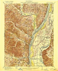
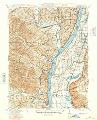
1916 Map of Kimmswick
USGS Topo · Published 1916About this map
The Mississippi River corridor south of Jefferson Barracks defines this 1916 landscape, where the river serves as both a busy thoroughfare and a stark boundary between Missouri and Illinois. On the Missouri side, the St Louis Iron Mountain and Southern railroad tracks hug the riverbank, connecting river towns like Kimmswick, Sulphur Springs, and the industrial hub of Herculaneum. The terrain here is marked by deep hollows and high bluffs, punctuated by family-named schools such as Bowles School and Soulard School that anchor small rural communities. Across the water in Illinois, the landscape shifts to the flat alluvial plains of Moredock and Harrisonville. The reliance on river transport is evident at Harrisonville Landing, while the fertile bottomlands are etched with remnants of former river channels like Moredock Lake and Long Lake No 1.
Find a feature on this map
96 named features on this map. Tap any name to fly to it.
Don’t see what you’re looking for? This feature index may not catch every label — zoom into the map to look around manually.
Map Details
Editions of this 1916 Kimmswick Map
6 editions found
Other maps of this area

1888 · St. Louis
USGS Topo · 1:62,500

1901 · De Soto
USGS Topo · 1:125,000

1903 · O'Fallon
USGS Topo · 1:125,000

1910 · Waterloo
USGS Topo · 1:62,500

1912 · Kimmswick
USGS Topo · 1:62,500

1913 · Waterloo
USGS Topo · 1:62,500

1915 · Renault
USGS Topo · 1:62,500

1915 · Crystal City
USGS Topo · 1:62,500

1916 · Kimmswick
USGS Topo · 1:62,500

1930 · De Soto NE
USGS Topo · 1:24,000