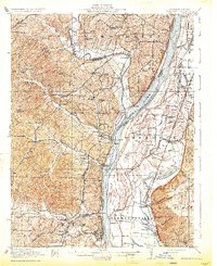
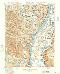
1916 Map of Kimmswick
USGS Topo · Published 1933About this map
Jefferson Barracks anchors the northern boundary of this 1910s landscape, where the Meramec River joins the Mississippi River near Cliff Cave. The terrain is defined by a dense network of country schools like Antonia School and Lone Dell School, serving rural communities connected by the Le May Ferry Road and Telegraph Road. Along the riverbanks, industrial and transport hubs such as Herculaneum and Kimmswick reflect the era's reliance on both water traffic at Harrisonville Landing and the St Louis Iron Mountain and Southern RR.
Find a feature on this map
94 named features on this map. Tap any name to fly to it.
Don’t see what you’re looking for? This feature index may not catch every label — zoom into the map to look around manually.
Map Details
Editions of this 1916 Kimmswick Map
6 editions found
Other maps of this area

1888 · St. Louis
USGS Topo · 1:62,500

1901 · De Soto
USGS Topo · 1:125,000

1903 · O'Fallon
USGS Topo · 1:125,000

1910 · Waterloo
USGS Topo · 1:62,500

1912 · Kimmswick
USGS Topo · 1:62,500

1913 · Waterloo
USGS Topo · 1:62,500

1915 · Renault
USGS Topo · 1:62,500

1915 · Crystal City
USGS Topo · 1:62,500

1916 · Kimmswick
USGS Topo · 1:62,500

1930 · De Soto NE
USGS Topo · 1:24,000