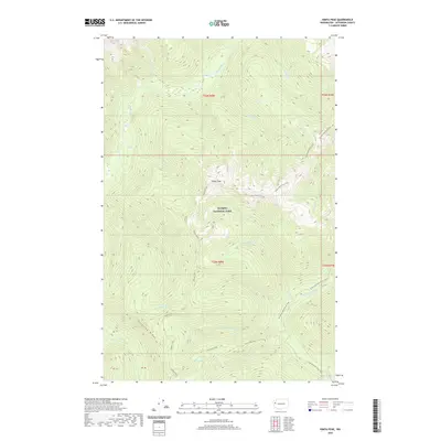
2020 Map of Kimta Peak
USGS Topo · Published 2020About this map
Olympic National Park defines this high-elevation landscape, where the headwaters of major river systems originate among steep ridges. The terrain is centered on Kimta Peak and the prominent Tshletshy Ridge, serving as a hydrological divide for the Queets River and its tributaries like Kilkelly Cr and Saghalle Cr. This environment is characterized by its network of backcountry paths, notably the Skyline Primitive Trail and the Skyline Trail, which traverse the high divides between remote water bodies such as Lake Beauty, Three Prune Lakes, and Kurtz Lake. Toward the southeast, the geography descends toward the N Fork Quinault River, where the N Fork Quinault River Trail follows the valley floor. The map documents a wilderness preserved from development, where only primitive trails and named watercourses like Hee-Hee Cr and Elip Cr mark the interior.
Find a feature on this map
30 named features on this map. Tap any name to fly to it.
Don’t see what you’re looking for? This feature index may not catch every label — zoom into the map to look around manually.
Map Details
Editions of this 2020 Kimta Peak Map
This is the sole edition of this map. No revisions or reprints were ever made.
Other maps of this area

1935 · Mount Olympus
USGS Topo · 1:62,500

1939 · Mount Tom
USGS Topo · 1:62,500

1942 · Mount Olympus
USGS Topo · 1:62,500

1947 · Mt Christie
USGS Topo · 1:62,500

1950 · Mt Christie
USGS Topo · 1:62,500

1956 · Mount Olympus
USGS Topo · 1:62,500

1956 · Kloochman Rock
USGS Topo · 1:62,500

1956 · Mount Tom
USGS Topo · 1:62,500
1957 · Mount Tom
USGS Topo · 1:62,500

1958 · Seattle
USGS Topo · 1:250,000