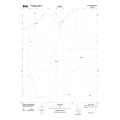
2011 Map of King Bench
USGS Topo · Published 2011About this map
The Gulch Outstanding Natural Area dominates the central portion of this Garfield County landscape, where the Escalante River winds through deep drainages. The map illustrates a transition from the elevated plains of King Bench to the intricate network of canyons including Hot Canyon, Long Canyon, and Wolverine Canyon. The primary corridor for travel remains the historic Burr Trl, which provides access to remote recreational facilities like the Deer Creek Campground and the Deer Creek Recreation Area. Water is the defining sculptor of this terrain, with the confluence of Deer Creek, Boulder Creek, and Steep Creek feeding into the main river system. This survey documents the preservation of public lands and the accessibility of these canyons in the early twenty-first century.
Find a feature on this map
14 named features on this map. Tap any name to fly to it.
Don’t see what you’re looking for? This feature index may not catch every label — zoom into the map to look around manually.
Map Details
Editions of this 2011 King Bench Map
This is the sole edition of this map. No revisions or reprints were ever made.
Other maps of this area

1886 · Escalante
USGS Topo · 1:250,000

1953 · Circle Cliffs 2 NE
USGS Topo · 1:24,000

1953 · Circle Cliffs 4 NW
USGS Topo · 1:24,000

1953 · Circle Cliffs 1 SW
USGS Topo · 1:24,000
1953 · Circle Cliffs 1 NW
USGS Topo · 1:24,000

1953 · Moody Creek
USGS Topo · 1:62,500
1953 · Wagon Box Mesa
USGS Topo · 1:62,500

1956 · Escalante
USGS Topo · 1:250,000

1960 · Escalante
USGS Topo · 1:250,000

1964 · Tenmile Flat
USGS Topo · 1:24,000