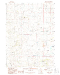
1987 Map of King Mountain
USGS Topo · Published 1987About this map
King Mountain stands as a central landmark in this high-altitude Wyoming landscape, where the headwaters of North Fork Horse Creek and Ricker Creek carve through the terrain. The presence of a solitary Schoolhouse along Spring Creek suggests a sparse but established rural community during the 1980s. The region's early industrial and geological interests are evidenced by marked Mines, Prospects, and a Quarry situated near the southern edge of the quadrangle. Steep drainages like Timber Canyon and Katie Brown Canyon define the area's geography, leading down toward the southern canyons. This survey captures a moment in the Laramie Range's history where ranching, resource extraction, and high-country hydrology intersect, preserved in meticulous detail by the USGS.
Find a feature on this map
19 named features on this map. Tap any name to fly to it.
Don’t see what you’re looking for? This feature index may not catch every label — zoom into the map to look around manually.
Map Details
Editions of this 1987 King Mountain Map
This is the sole edition of this map. No revisions or reprints were ever made.
Other maps of this area

1895 · Laramie
USGS Topo · 1:125,000

1902 · Laramie
USGS Topo · 1:125,000

1905 · Sherman
USGS Topo · 1:125,000

1905 · Laramie
USGS Topo · 1:125,000

1906 · Laramie
USGS Topo · 1:125,000

1908 · Laramie
USGS Topo · 1:125,000

1948 · Ragged Top Mountain
USGS Topo · 1:62,500

1950 · Ragged Top Mountain
USGS Topo · 1:62,500

1954 · Cheyenne
USGS Topo · 1:250,000

1955 · Bosler SE
USGS Topo · 1:24,000