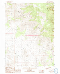
1991 Map of King Top
USGS Topo · Published 1991About this map
The Confusion Range of western Utah is the central focus of this 1991 survey, which depicts a landscape defined by sharp elevation changes and numerous named drainage systems. The summit of King Top dominates the northeast, while the Snake Pass Road provides the primary transit route through the southwestern portion of the quadrangle. This area is characterized by a dense network of canyons, including Jackson Canyon, Noddy Canyon, and Cedar Canyon, which carve through the high terrain.
Find a feature on this map
16 named features on this map. Tap any name to fly to it.
Don’t see what you’re looking for? This feature index may not catch every label — zoom into the map to look around manually.
Map Details
Editions of this 1991 King Top Map
This is the sole edition of this map. No revisions or reprints were ever made.
Other maps of this area

1908 · Fish Springs
USGS Topo · 1:250,000

1910 · Fish Springs
USGS Topo · 1:250,000

1953 · Richfield
USGS Topo · 1:250,000

1953 · Delta
USGS Topo · 1:250,000

1958 · Richfield
USGS Topo · 1:250,000

1958 · Delta
USGS Topo · 1:250,000

1960 · Notch Peak
USGS Topo · 1:62,500

1960 · Crystal Peak
USGS Topo · 1:62,500

1960 · Conger Mountain
USGS Topo · 1:62,500

1960 · The Barn
USGS Topo · 1:62,500