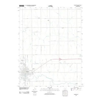
2009 Map of Kingman
USGS Topo · Published 2009About this map
Kingman serves as the primary center of activity in this south-central Kansas landscape, situated along the South Fork Ninnescah River. The town's grid is well-established, featuring landmarks like the Kingman Municipal Airport and the Walnut Hill Cemetery on its eastern edge. Beyond the town limits, the geography shifts to a systematic agricultural grid defined by county roads such as Maple Grove Rd and NE 60 St. This rural expanse is punctuated by the small settlements of Varner to the north and Georgia in the southeast corner. The drainage of Smoots Creek meanders through the northern sections, illustrating the natural water patterns that influenced early homesteading and land use. For those researching local history, the location of Schooley Cemetery in the northern reaches of the quadrangle offers a specific point of interest for genealogical study within the prairie landscape.
Find a feature on this map
43 named features on this map. Tap any name to fly to it.
Don’t see what you’re looking for? This feature index may not catch every label — zoom into the map to look around manually.
Map Details
Editions of this 2009 Kingman Map
This is the sole edition of this map. No revisions or reprints were ever made.
Other maps of this area

1889 · Cheney
USGS Topo · 1:125,000

1891 · Cheney
USGS Topo · 1:125,000

1892 · Kingman
USGS Topo · 1:125,000

1894 · Kingman
USGS Topo · 1:125,000

1901 · Cheney
USGS Topo · 1:125,000

1955 · Wichita
USGS Topo · 1:250,000

1955 · Pratt
USGS Topo · 1:250,000

1958 · Wichita
USGS Topo · 1:250,000

1959 · Pratt
USGS Topo · 1:250,000
1965 · Waterloo
USGS Topo · 1:24,000