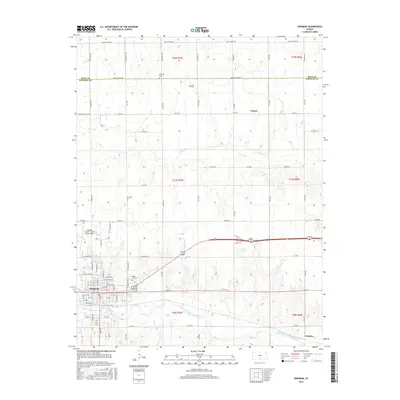
2016 Map of Kingman
USGS Topo · Published 2016About this map
Kingman serves as the primary hub of activity on the southern edge of this landscape, situated along the South Fork Ninnescah River. The town's layout is meticulously detailed, showing a grid of streets including N Main St and W Kansas Ave. To the west, the Kingman Airport - Clyde Cessna Field underscores the aviation heritage of the region. The map reveals a predominately agricultural character, defined by a rigid section-line road network that includes Centennial Rd and Maple Grove Rd.
Find a feature on this map
85 named features on this map. Tap any name to fly to it.
Don’t see what you’re looking for? This feature index may not catch every label — zoom into the map to look around manually.
Map Details
Editions of this 2016 Kingman Map
This is the sole edition of this map. No revisions or reprints were ever made.
Other maps of this area

1889 · Cheney
USGS Topo · 1:125,000

1891 · Cheney
USGS Topo · 1:125,000

1892 · Kingman
USGS Topo · 1:125,000

1894 · Kingman
USGS Topo · 1:125,000

1901 · Cheney
USGS Topo · 1:125,000

1955 · Wichita
USGS Topo · 1:250,000

1955 · Pratt
USGS Topo · 1:250,000

1958 · Wichita
USGS Topo · 1:250,000

1959 · Pratt
USGS Topo · 1:250,000
1965 · Waterloo
USGS Topo · 1:24,000