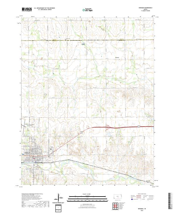
2022 Map of Kingman
USGS Topo · Published 2022About this map
The South Fork Ninnescah River flows through the southern half of this Kansas landscape, anchoring the settlement of Kingman, which serves as a central hub for the surrounding agricultural region. The town is marked by civic and transit landmarks, including the Kingman County Courthouse and the Kingman Airport/Clyde Cessna Field. This 2022 survey illustrates the transition from the organized street grid of the town to the wide-reaching sectional road network that defines the rural periphery. Small historic settlements like Varner and Georgia are noted along these routes, while the Walnut Hill Cem and Schooley Cem provide important reference points for genealogical research. Water features like Lakin Lake and Smoots Creek punctuate the plains, revealing the natural drainage patterns of the Ninnescah river valley.
Find a feature on this map
82 named features on this map. Tap any name to fly to it.
Don’t see what you’re looking for? This feature index may not catch every label — zoom into the map to look around manually.
Map Details
Editions of this 2022 Kingman Map
This is the sole edition of this map. No revisions or reprints were ever made.
Other maps of this area

1889 · Cheney
USGS Topo · 1:125,000

1891 · Cheney
USGS Topo · 1:125,000

1892 · Kingman
USGS Topo · 1:125,000

1894 · Kingman
USGS Topo · 1:125,000

1901 · Cheney
USGS Topo · 1:125,000

1955 · Wichita
USGS Topo · 1:250,000

1955 · Pratt
USGS Topo · 1:250,000

1958 · Wichita
USGS Topo · 1:250,000

1959 · Pratt
USGS Topo · 1:250,000
1965 · Waterloo
USGS Topo · 1:24,000