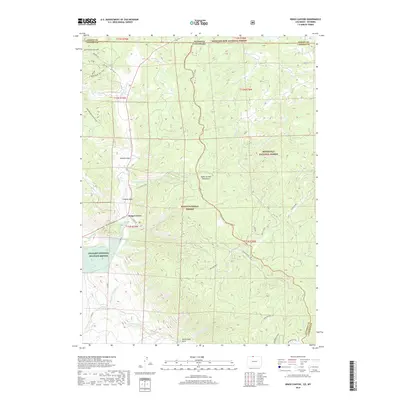
2019 Map of Kings Canyon
USGS Topo · Published 2019About this map
Kings Canyon serves as a central point in this high-altitude landscape where the borders of four major protected areas converge. The terrain is defined by the Medicine Bow Mountains and several alpine parks, including Bluebird Park and Clayton Park. Water management is a visible priority in this environment, as evidenced by the engineering of the Allard Ditch and Hardwork Ditch, which divert mountain runoff through the valley. These irrigation features are indicative of the region's ranching and agricultural requirements despite the significant presence of federally managed lands. The southern portion of the map is dominated by the unique geography of the North Sand Hills, while the western edge reaches into the Arapaho National Wildlife Refuge. This intersection of conservation and resource management is further illustrated by the meeting of the Routt, Medicine Bow, and Roosevelt National Forest boundaries.
Find a feature on this map
35 named features on this map. Tap any name to fly to it.
Don’t see what you’re looking for? This feature index may not catch every label — zoom into the map to look around manually.
Map Details
Editions of this 2019 Kings Canyon Map
This is the sole edition of this map. No revisions or reprints were ever made.
Other maps of this area

1906 · Medicine Bow
USGS Topo · 1:125,000

1908 · Medicine Bow
USGS Topo · 1:125,000

1950 · Northgate
USGS Topo · 1:24,000

1950 · Kings Canyon
USGS Topo · 1:24,000

1952 · Northgate
USGS Topo · 1:24,000

1952 · Kings Canyon
USGS Topo · 1:24,000

1954 · Rawlins
USGS Topo · 1:250,000

1954 · Craig
USGS Topo · 1:250,000

1955 · Old Roach
USGS Topo · 1:24,000

1955 · Eagle Hill
USGS Topo · 1:24,000