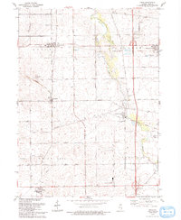
1993 Map of Kings
USGS Topo · Published 1993About this map
Davis Junction and Lindenwood anchor this survey of rural Ogle County, where the agricultural landscape is divided by the meandering Kilbuck Creek and Stillman Creek. The map documents a late-twentieth-century transition in transport, showing the Old Railroad Grade alongside modern infrastructure like Interchange 111 and the Landing Strip near Lynnville. Small hamlets such as Holcomb and White Rock Center remain distinct centers of activity, while family and community history is preserved at the Kilbuck Cem, Big Mound Cem, and Lindenwood Cem. The presence of several Radio Towers and a Radio Facility suggests the area's role in regional communications. From the Quarry near Monroe Center to the Gravel Pit further south, the map details the local extractive industries that shaped the terrain between Big Mound and the surrounding creek beds.
Find a feature on this map
46 named features on this map. Tap any name to fly to it.
Don’t see what you’re looking for? This feature index may not catch every label — zoom into the map to look around manually.
Map Details
Editions of this 1993 Kings Map
This is the sole edition of this map. No revisions or reprints were ever made.
Other maps of this area

1917 · Kings
USGS Topo · 1:62,500

1918 · Kings
USGS Topo · 1:62,500

1918 · Kirkland
USGS Topo · 1:62,500

1934 · De Kalb
USGS Topo · 1:62,500

1937 · De Kalb
USGS Topo · 1:62,500

1949 · Camp Grant
USGS Topo · 1:24,000

1952 · Rochelle
USGS Topo · 1:62,500

1954 · Rockford
USGS Topo · 1:250,000

1955 · Rockford
USGS Topo · 1:250,000

1958 · Aurora
USGS Topo · 1:250,000