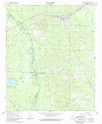
1966 Map of Kingsland
USGS Topo · Published 1986About this map
The St Louis Southwestern railroad cuts a diagonal path through the timbered landscape of southern Cleveland County, anchoring the town of Kingsland. This mid-century survey captures a rural Arkansas landscape defined by the winding course of Moro Creek, which serves as a natural boundary between Cleveland, Dallas, and Calhoun Counties. Significant water features like Tri-County Lake and the Saline River illustrate the hydrology of the Gulf Coastal Plain, while the presence of the Moro Lookout Tower indicates the importance of forest management during this era. Genealogists will find a wealth of local landmarks, including several rural burial grounds such as Kingsland Cem, Morgan Cem, and McCoy Cem. The map also documents local infrastructure ranging from the Fordyce Airport to small country houses of worship like Smith Ch and Mt Lebanon Ch.
Find a feature on this map
24 named features on this map. Tap any name to fly to it.
Don’t see what you’re looking for? This feature index may not catch every label — zoom into the map to look around manually.
Map Details
Editions of this 1966 Kingsland Map
2 editions found
Other maps of this area

1953 · El Dorado
USGS Topo · 1:250,000

1957 · El Dorado
USGS Topo · 1:250,000

1958 · El Dorado
USGS Topo · 1:250,000

1960 · El Dorado
USGS Topo · 1:250,000

1966 · Kingsland
USGS Topo · 1:24,000

1966 · Fordyce
USGS Topo · 1:24,000
1969 · Ivan
USGS Topo · 1:24,000
1970 · Fordyce NE
USGS Topo · 1:24,000

1970 · New Edinburg
USGS Topo · 1:24,000
1970 · Rison
USGS Topo · 1:24,000