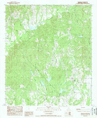
1988 Map of Kingston
USGS Topo · Published 1988About this map
Kingston and the surrounding drainage basins of Adams County are meticulously documented in this 1980s topographical record. The landscape is defined by an intricate network of waterways, including Second Bayou, Lynn Creek, and Turkey Creek, which carve through the terrain south of Natchez. Small settlements like Ogden and the localized Tango area appear alongside industrial and utility infrastructure, such as a Sand & Gravel Pit, a Pipeline, and a Pumping Station.
Find a feature on this map
23 named features on this map. Tap any name to fly to it.
Don’t see what you’re looking for? This feature index may not catch every label — zoom into the map to look around manually.
Map Details
Editions of this 1988 Kingston Map
This is the sole edition of this map. No revisions or reprints were ever made.
Other maps of this area

1909 · Vidalia
USGS Topo · 1:24,000

1921 · Natchez
USGS Topo · 1:48,000

1922 · Natchez
USGS Topo · 1:62,500

1939 · Natchez
USGS Topo · 1:62,500

1939 · Kingston
USGS Topo · 1:62,500

1953 · Natchez
USGS Topo · 1:250,000

1956 · Natchez
USGS Topo · 1:250,000

1958 · Kingston
USGS Topo · 1:62,500

1959 · Natchez
USGS Topo · 1:250,000

1961 · Crosby
USGS Topo · 1:62,500