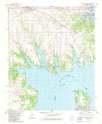
1982 Map of Kingston South
USGS Topo · Published 1983About this map
The vast expanse of Lake Texoma dominates the landscape of this early 1980s survey, illustrating the significant impact of the impounded Red River on the border between Oklahoma and Texas. The reservoir’s intricate shoreline has created numerous peninsulas and bays, such as Catfish Bay and Preston Peninsula, which by this time had become hubs for recreation at Lake Texoma State Park and various public use areas. In the southern portion, the Preston settlement occupies a finger of land extending into the lake, while the community of Kingston remains a focal point in the north along the Burlington Northern railroad.
Find a feature on this map
49 named features on this map. Tap any name to fly to it.
Don’t see what you’re looking for? This feature index may not catch every label — zoom into the map to look around manually.
Map Details
Editions of this 1982 Kingston South Map
2 editions found
Other maps of this area

1901 · Tishomingo
USGS Topo · 1:125,000

1901 · Denison
USGS Topo · 1:125,000

1954 · Sherman
USGS Topo · 1:250,000

1957 · Denison Dam
USGS Topo · 1:24,000

1957 · Ardmore
USGS Topo · 1:250,000

1958 · Gordonville
USGS Topo · 1:62,500

1958 · Denison Dam
USGS Topo · 1:62,500

1958 · Sherman
USGS Topo · 1:250,000

1963 · Ardmore
USGS Topo · 1:250,000

1963 · Madill
USGS Topo · 1:24,000