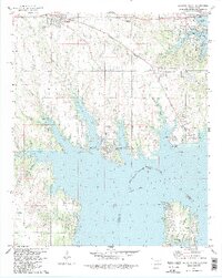
1982 Map of Kinston South
USGS Topo · Published 1983About this map
The waters of Lake Texoma dominate this 1982 landscape, where the Red River defines the border between Oklahoma and Texas. The infrastructure of the era is represented by the Burlington Northern railroad and the Roosevelt Memorial Bridge crossing the northern reaches of the lake. Local heritage is preserved through numerous family and community sites, including Isom Springs Cem, Hainline Cem, and Preston Bend Cem on the Preston Peninsula. The map details the transition from traditional agriculture and early industry, seen in the western Oil Field, to a growing recreational economy focused around Lake Texoma State Park, Catfish Bay, and several public use areas. Smaller settlements like Woodville, McBride, and Preston anchor the rural landscape away from the town of Kingston.
Find a feature on this map
51 named features on this map. Tap any name to fly to it.
Don’t see what you’re looking for? This feature index may not catch every label — zoom into the map to look around manually.
Map Details
Editions of this 1982 Kinston South Map
2 editions found
Other maps of this area

1901 · Tishomingo
USGS Topo · 1:125,000

1901 · Denison
USGS Topo · 1:125,000

1954 · Sherman
USGS Topo · 1:250,000

1957 · Denison Dam
USGS Topo · 1:24,000

1957 · Ardmore
USGS Topo · 1:250,000

1958 · Gordonville
USGS Topo · 1:62,500

1958 · Denison Dam
USGS Topo · 1:62,500

1958 · Sherman
USGS Topo · 1:250,000

1963 · Ardmore
USGS Topo · 1:250,000

1963 · Madill
USGS Topo · 1:24,000