
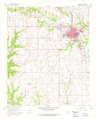
1963 Map of Madill
USGS Topo · Published 1964About this map
The St Louis - San Francisco railroad corridor anchors this mid-century portrait of Marshall County, where the growing street grid of Madill meets the surrounding agricultural landscape. The town center is densely detailed with municipal landmarks, including the local Courthouse, Post Office, and schools such as Will Rogers Sch and the Jr High Sch. To the northwest, the smaller settlement of Oakland sits near the shores of City Lake, while the unincorporated community of Glasses borders Glasses Creek.
Find a feature on this map
37 named features on this map. Tap any name to fly to it.
Don’t see what you’re looking for? This feature index may not catch every label — zoom into the map to look around manually.
Map Details
Editions of this 1963 Madill Map
2 editions found
Other maps of this area

1901 · Tishomingo
USGS Topo · 1:125,000

1901 · Denison
USGS Topo · 1:125,000

1954 · Sherman
USGS Topo · 1:250,000

1957 · Ardmore
USGS Topo · 1:250,000

1958 · Gordonville
USGS Topo · 1:62,500

1958 · Denison Dam
USGS Topo · 1:62,500

1958 · Sherman
USGS Topo · 1:250,000

1963 · Ardmore
USGS Topo · 1:250,000

1963 · Mannsville
USGS Topo · 1:24,000

1963 · Ravia
USGS Topo · 1:24,000