
1963 Map of Ravia
USGS Topo · Published 1964About this map
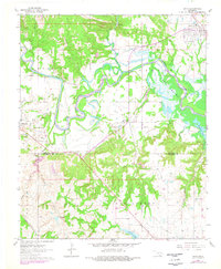
Ravia sits at the northern edge of this landscape where the St Louis-San Francisco railroad cuts through the terrain. The sprawling meanders of the Washita River dominate the central portion of the map, leading into the upper reaches of Washita River Lake Texoma. This mid-century survey reveals a rural economy shaped by both agriculture and resource extraction, evidenced by numerous Gravel Pits and clusters of Oil Wells south of Mannsville. Genealogical interest is found in the scattered community landmarks such as Russett Ch and Russett Cem in the small settlement of Russett. The map also documents the older transportation network, including an Old Railroad Grade and numerous section-line roads that define the borders between Johnston and Marshall Counties. Smaller water bodies like Carter Lake and Randolph Lake punctuate the southern half, while the northern hills are marked by the Ratliff and Garner terrain labels.
Find a feature on this map
32 named features on this map. Tap any name to fly to it.
Don’t see what you’re looking for? This feature index may not catch every label — zoom into the map to look around manually.
Map Details
Editions of this 1963 Ravia Map
2 editions found
Other maps of this area

1901 · Tishomingo
USGS Topo · 1:125,000

1957 · Ardmore
USGS Topo · 1:250,000

1963 · Ardmore
USGS Topo · 1:250,000

1963 · Madill
USGS Topo · 1:24,000

1963 · Mannsville
USGS Topo · 1:24,000

1963 · Troy
USGS Topo · 1:24,000

1963 · Mc Millan
USGS Topo · 1:24,000

1963 · Nebo
USGS Topo · 1:24,000
1967 · Tishomingo SW
USGS Topo · 1:24,000

1967 · Tishomingo
USGS Topo · 1:24,000