
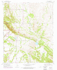
1963 Map of Nebo
USGS Topo · Published 1964About this map
The Washita River snakes through this southern Oklahoma landscape, defining the topography where Carter, Murray, and Johnston counties converge. In the early 1960s, the rural character of the region is centered around small communities like Nebo and Baum, which remain hubs for local life and education at the Nebo Sch. The map reveals a land utilized for both agriculture and industry, marked by numerous Gravel Pits and a Quarry dotting the terrain. Transportation and infrastructure are highlighted by the Ardmore Municipal Airport in the west and a secluded Landing Strip further east. For genealogists, the map is a vital resource, preserving the locations of family and community resting places such as Young Cem, Hutchins Cem, and Lone Cedar Cem, often situated near winding tributaries like Denmark Creek and Oil Creek.
Find a feature on this map
24 named features on this map. Tap any name to fly to it.
Don’t see what you’re looking for? This feature index may not catch every label — zoom into the map to look around manually.
Map Details
Editions of this 1963 Nebo Map
2 editions found
Other maps of this area

1901 · Tishomingo
USGS Topo · 1:125,000

1901 · Ardmore
USGS Topo · 1:125,000

1918 · Ardmore
USGS Topo · 1:125,000

1957 · Ardmore
USGS Topo · 1:250,000

1963 · Ardmore
USGS Topo · 1:250,000

1963 · Mannsville
USGS Topo · 1:24,000

1963 · Sulphur South
USGS Topo · 1:24,000

1963 · Mill Creek
USGS Topo · 1:24,000

1963 · Troy
USGS Topo · 1:24,000

1963 · Ravia
USGS Topo · 1:24,000