
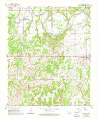
1963 Map of Mannsville
USGS Topo · Published 1964About this map
The Washita River carves a dramatic, meandering path across this Southern Oklahoma landscape, defining the northern border of the territory. This early 1960s survey documents the rural communities of Mannsville and Dickson as they appeared before major modern highway expansions altered the local character. Centered on the intersection of the St Louis - San Francisco railroad and the town of Mannsville, the map reveals a network of small settlements and family-named locations such as Earl and Simpson.
Find a feature on this map
32 named features on this map. Tap any name to fly to it.
Don’t see what you’re looking for? This feature index may not catch every label — zoom into the map to look around manually.
Map Details
Editions of this 1963 Mannsville Map
2 editions found
Other maps of this area

1901 · Tishomingo
USGS Topo · 1:125,000

1901 · Ardmore
USGS Topo · 1:125,000

1918 · Ardmore
USGS Topo · 1:125,000

1957 · Ardmore
USGS Topo · 1:250,000

1963 · Ardmore
USGS Topo · 1:250,000

1963 · Madill
USGS Topo · 1:24,000

1963 · Troy
USGS Topo · 1:24,000

1963 · Ravia
USGS Topo · 1:24,000

1963 · Mc Millan
USGS Topo · 1:24,000

1963 · Nebo
USGS Topo · 1:24,000