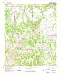
1963 Map of Mannsville
USGS Topo · Published 1978About this map
The Washita River snakes across the northern landscape of this Oklahoma survey, defining the boundary between the Berwyn and Ratliff districts. This area, spanning the borders of Carter, Johnston, and Marshall counties, shows a rural economy centered on the St Louis San Francisco railroad line which serves the community of Simpson. Local life in the mid-20th century is anchored by small settlements like Mannsville and Durwood, the latter featuring a clustered community infrastructure including the Durwood Ch and Durwood Sch. The map preserves the locations of several family and community burial grounds, such as Thomas Cem and Earl Cem, alongside industrial markers like Gravel Pits and a Quarry. To the south, the topography transitions into the Holford region, drained by Little Hawani Creek, while an older Railroad Grade near Earl hints at earlier transportation corridors.
Find a feature on this map
34 named features on this map. Tap any name to fly to it.
Don’t see what you’re looking for? This feature index may not catch every label — zoom into the map to look around manually.
Map Details
Editions of this 1963 Mannsville Map
2 editions found
Other maps of this area

1901 · Tishomingo
USGS Topo · 1:125,000

1901 · Ardmore
USGS Topo · 1:125,000

1918 · Ardmore
USGS Topo · 1:125,000

1957 · Ardmore
USGS Topo · 1:250,000

1963 · Ardmore
USGS Topo · 1:250,000

1963 · Madill
USGS Topo · 1:24,000

1963 · Mannsville
USGS Topo · 1:24,000

1963 · Troy
USGS Topo · 1:24,000

1963 · Ravia
USGS Topo · 1:24,000

1963 · Mc Millan
USGS Topo · 1:24,000