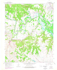
1963 Map of Ravia
USGS Topo · Published 1978About this map
The Washita River meanders through the heart of this Johnston County landscape, feeding into the upper reaches of Lake Texoma where it meets the Johnston Co Marshall Co line. This mid-century view captures a transition in the local infrastructure, showing the corridor of the St Louis - San Francisco railroad as it serves the town of Ravia, while the southern reaches near the Madill Municipal Airport show an evolving landscape of transportation and resource extraction. Smaller settlements like Russett and Mannsville anchor the western and central portions of the sheet, characterized by local landmarks such as Russett Ch and Russett Cem. The presence of numerous extractive features, including Gravel Pits and Oil Wells, illustrates the area's economic reliance on the land, while the placement of Cedar Hill Cem provides a tangible link for those researching the genealogy of this Oklahoma river valley.
Find a feature on this map
31 named features on this map. Tap any name to fly to it.
Don’t see what you’re looking for? This feature index may not catch every label — zoom into the map to look around manually.
Map Details
Editions of this 1963 Ravia Map
2 editions found
Other maps of this area

1901 · Tishomingo
USGS Topo · 1:125,000

1957 · Ardmore
USGS Topo · 1:250,000

1963 · Ardmore
USGS Topo · 1:250,000

1963 · Madill
USGS Topo · 1:24,000

1963 · Mannsville
USGS Topo · 1:24,000

1963 · Troy
USGS Topo · 1:24,000

1963 · Ravia
USGS Topo · 1:24,000

1963 · Mc Millan
USGS Topo · 1:24,000

1963 · Nebo
USGS Topo · 1:24,000
1967 · Tishomingo SW
USGS Topo · 1:24,000