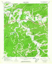
1966 Map of Kingston Springs
USGS Topo · Published 1967About this map
The Harpeth River carves a winding course through this mid-1960s landscape, defining the character of western Middle Tennessee. The river's dramatic oxbows frame the communities of Kingston Springs and Pegram, where the Louisville and Nashville railroad tracks parallel the water, underscoring the corridor's historic role in transport. The terrain is marked by significant topographical variation, from Sullivan Ridge in the northeast to the deeply etched valleys of Hatcher Hollow and Bell Hollow.
Find a feature on this map
49 named features on this map. Tap any name to fly to it.
Don’t see what you’re looking for? This feature index may not catch every label — zoom into the map to look around manually.
Map Details
Editions of this 1966 Kingston Springs Map
4 editions found
Other maps of this area

1901 · Colombia
USGS Topo · 1:125,000

1903 · Nashville
USGS Topo · 1:125,000

1909 · Franklin
USGS Topo · 1:62,500

1930 · White Bluff
USGS Topo · 1:62,500

1932 · Nashville
USGS Topo · 1:62,500

1933 · White Bluff
USGS Topo · 1:62,500

1936 · Craigfield
USGS Topo · 1:24,000

1946 · Leipers Fork
USGS Topo · 1:24,000

1949 · Leipers Fork
USGS Topo · 1:24,000

1951 · Fairview
USGS Topo · 1:24,000