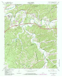
1966 Map of Kingston Springs
USGS Topo · Published 1984About this map
The Harpeth River and South Harpeth River wind through the deeply dissected uplands of Middle Tennessee, defining the character of the settlements at Kingston Springs and Pegram. This mid-century survey captures a landscape of transition, where established farming communities along Harding Pike and Old Charlotte Road met the expanding infrastructure of the Seaboard System railroad. The map records the local social fabric through landmarks like Cave Springs Sch, Westview Chapel, and the Harpeth Hills Memory Gardens.
Find a feature on this map
60 named features on this map. Tap any name to fly to it.
Don’t see what you’re looking for? This feature index may not catch every label — zoom into the map to look around manually.
Map Details
Editions of this 1966 Kingston Springs Map
4 editions found
Other maps of this area

1901 · Colombia
USGS Topo · 1:125,000

1903 · Nashville
USGS Topo · 1:125,000

1909 · Franklin
USGS Topo · 1:62,500

1930 · White Bluff
USGS Topo · 1:62,500

1932 · Nashville
USGS Topo · 1:62,500

1933 · White Bluff
USGS Topo · 1:62,500

1936 · Craigfield
USGS Topo · 1:24,000

1946 · Leipers Fork
USGS Topo · 1:24,000

1949 · Leipers Fork
USGS Topo · 1:24,000

1951 · Fairview
USGS Topo · 1:24,000