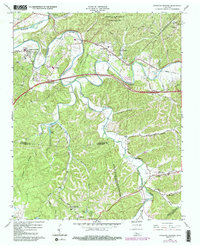
1966 Map of Kingston Springs
USGS Topo · Published 1984About this map
The Harpeth River winds through the hills of Cheatham and Williamson Counties, defining the development of Kingston Springs and Pegram in the mid-1960s. This survey, updated with 1980s aerial data, shows a landscape transitioning between its rural roots and growing civic infrastructure, evidenced by the South Cheatham High Sch and the Seaboard railroad corridor. The rugged terrain is carved by numerous drainages like Dog Creek and Poplar Creek, while the north is dominated by the Cheatham State Wildlife Management Area. Local history is deeply embedded in the land, from the scattered headstones of Mt Pleasant Cem and Thornton Cem to the early religious centers at Wards Chapel and Westview Chapel. Small pockets of recreation and industry are also visible, including Camp Marymount and a riverside Quarry.
Find a feature on this map
54 named features on this map. Tap any name to fly to it.
Don’t see what you’re looking for? This feature index may not catch every label — zoom into the map to look around manually.
Map Details
Editions of this 1966 Kingston Springs Map
4 editions found
Other maps of this area

1901 · Colombia
USGS Topo · 1:125,000

1903 · Nashville
USGS Topo · 1:125,000

1909 · Franklin
USGS Topo · 1:62,500

1930 · White Bluff
USGS Topo · 1:62,500

1932 · Nashville
USGS Topo · 1:62,500

1933 · White Bluff
USGS Topo · 1:62,500

1936 · Craigfield
USGS Topo · 1:24,000

1946 · Leipers Fork
USGS Topo · 1:24,000

1949 · Leipers Fork
USGS Topo · 1:24,000

1951 · Fairview
USGS Topo · 1:24,000