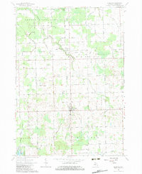
1963 Map of Kingston
USGS Topo · Published 1983About this map
The village of Kingston sits at the heart of this agricultural region in Michigan's Thumb, serving as a hub for the surrounding townships of Ellington, Dayton, and Koylton. Grounded in the early 1960s, the map reveals a landscape defined by an extensive network of drainage systems such as White Creek and Sucker Creek, which supported the productive farmland of Tuscola County. The Grand Trunk Railroad cuts east-west through the northern half of the sheet, linking the community of Wilmot to the wider Michigan rail network. To the north, the Deford State Game Area provides a shift from cultivated fields to managed conservation land. Local life is anchored by landmarks like St Michaels Ch, Beverly Sch, and the cluster of Gravel Pits that suggest a quiet but steady rural economy during this period.
Find a feature on this map
69 named features on this map. Tap any name to fly to it.
Don’t see what you’re looking for? This feature index may not catch every label — zoom into the map to look around manually.
Map Details
Editions of this 1963 Kingston Map
2 editions found
Other maps of this area

1954 · Flint
USGS Topo · 1:250,000

1958 · Flint
USGS Topo · 1:250,000

1963 · Clifford
USGS Topo · 1:24,000

1963 · East Dayton
USGS Topo · 1:24,000

1963 · Mayville
USGS Topo · 1:24,000

1963 · Marlette
USGS Topo · 1:24,000

1963 · Kingston
USGS Topo · 1:24,000

1963 · Cass City
USGS Topo · 1:24,000

1963 · Ellington
USGS Topo · 1:24,000

1963 · Shabbona
USGS Topo · 1:24,000