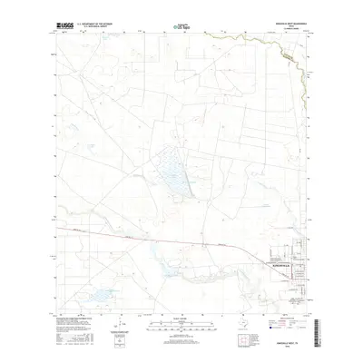
2016 Map of Kingsville West
USGS Topo · Published 2016About this map
Texas A & M University-Kingsville serves as the academic and cultural anchor for the western edge of Kingsville, situated where the city grid meets the South Texas plains. The landscape is defined by a sophisticated system of water management and natural drainages, including the meandering San Fernando Cr which forms the border between Nueces and Kleberg counties. Ranching and agricultural heritage is evident in the numerous stock tanks and engineered water bodies like Tranquitas Lake and Tuloso Reservoir Number 3 Lake. Beyond the residential streets of Kingsville, the terrain is marked by ephemeral features such as Posta Water-Hole and the seasonal flows of Santa Gertrudis Cr. On the southern edge of town, the Gertrudis Memorial Cem and Chamberlain Cem provide significant points of interest for genealogists tracing the community's local lineage.
Find a feature on this map
34 named features on this map. Tap any name to fly to it.
Don’t see what you’re looking for? This feature index may not catch every label — zoom into the map to look around manually.
Map Details
Editions of this 2016 Kingsville West Map
This is the sole edition of this map. No revisions or reprints were ever made.
Other maps of this area

1917 · Ben Bolt
USGS Topo · 1:62,500

1921 · Falfurrias
USGS Topo · 1:125,000

1928 · Sarita
USGS Topo · 1:125,000

1950 · Corpus Christi
USGS Topo · 1:250,000

1954 · Kingsville
USGS Topo · 1:62,500

1954 · Riviera
USGS Topo · 1:62,500

1956 · Corpus Christi
USGS Topo · 1:250,000

1956 · Laredo
USGS Topo · 1:250,000

1960 · Corpus Christi
USGS Topo · 1:250,000

1963 · Ben Bolt SE
USGS Topo · 1:24,000