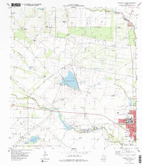
1979 Map of Kingsville West
USGS Topo · Published 1979About this map
King Ranch and the expansive Stratton Oil Field dominate this South Texas landscape, illustrating the intersection of historic ranching and the petroleum industry in the late 1970s. The western edge of Kingsville is anchored by the campus of Texas A&I University, while the surrounding countryside is dotted with countless named windmills such as Arredondo Windmill and Mota Huisache Windmill, essential for water in this arid terrain. Drainage is defined by the winding paths of Tranquitas Creek and Santa Gertrudis Creek, which feed several small bodies of water including Tranquitas Lake and Tulosa Lake. The presence of Santo Gertrudis Memorial Cem and Chamberlain Cemetery provides clear reference points for genealogists. This survey reveals a working landscape where oil infrastructure, represented by the West Stratton Oil Field and the Stratton Pumping Station, coexists with traditional ranching grounds and local landmarks like the Race Track.
Find a feature on this map
35 named features on this map. Tap any name to fly to it.
Don’t see what you’re looking for? This feature index may not catch every label — zoom into the map to look around manually.
Map Details
Editions of this 1979 Kingsville West Map
This is the sole edition of this map. No revisions or reprints were ever made.
Other maps of this area

1917 · Ben Bolt
USGS Topo · 1:62,500

1921 · Falfurrias
USGS Topo · 1:125,000

1928 · Sarita
USGS Topo · 1:125,000

1950 · Corpus Christi
USGS Topo · 1:250,000

1954 · Kingsville
USGS Topo · 1:62,500

1954 · Riviera
USGS Topo · 1:62,500

1956 · Corpus Christi
USGS Topo · 1:250,000

1956 · Laredo
USGS Topo · 1:250,000

1960 · Corpus Christi
USGS Topo · 1:250,000

1963 · Ben Bolt SE
USGS Topo · 1:24,000