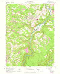
1960 Map of Kingwood
USGS Topo · Published 1978About this map
The Cheat River carves a deep valley through this Preston County landscape, serving as a corridor for the Baltimore and Ohio railroad and the National Guard Camp Dawson. In the mid-20th century, the area around the county seat of Kingwood reflects a transition between established ridge-top settlements and the expanding reach of extractive industry. Numerous labels for Strip Mines and several quarries indicate the intensive resource gathering that defined the local economy during this era.
Find a feature on this map
58 named features on this map. Tap any name to fly to it.
Don’t see what you’re looking for? This feature index may not catch every label — zoom into the map to look around manually.
Map Details
Editions of this 1960 Kingwood Map
4 editions found
Other maps of this area

1886 · St. George
USGS Topo · 1:125,000

1891 · St. George
USGS Topo · 1:125,000

1902 · Morgantown
USGS Topo · 1:62,500

1904 · Bruceton
USGS Topo · 1:62,500

1907 · Thornton
USGS Topo · 1:62,500

1907 · Kingwood
USGS Topo · 1:62,500

1925 · Kingwood
USGS Topo · 1:62,500

1925 · Morgantown
USGS Topo · 1:62,500

1926 · Thornton
USGS Topo · 1:62,500

1926 · Bruceton
USGS Topo · 1:62,500