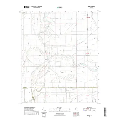
2018 Map of Kinlock
USGS Topo · Published 2018About this map
The Big Sunflower River winds through this section of the Mississippi Delta, defining the boundary between Washington, Sunflower, and Humphreys counties. The small settlement of Kinlock serves as a focal point in a landscape dominated by agricultural reaches and complex hydrology, including Wildcat Bayou, Dutch Brake, and Bogue Phalia. Evidence of the region's long human history is marked by Prentiss Mound near the eastern edge of the survey. Local infrastructure is geared toward the Delta's aviation and agricultural needs, as seen with Lang Flying Service. Genealogists may find value in the locations of Hickory Bluff Cem and Pilgrim Rest Cem, while the network of plantation-named roads like Brumfield Plantation Rd reflects the historic land-use patterns of this fertile alluvial plain.
Find a feature on this map
63 named features on this map. Tap any name to fly to it.
Don’t see what you’re looking for? This feature index may not catch every label — zoom into the map to look around manually.
Map Details
Editions of this 2018 Kinlock Map
This is the sole edition of this map. No revisions or reprints were ever made.
Other maps of this area

1939 · Tralake
USGS Topo · 1:62,500

1939 · Swan Lake
USGS Topo · 1:62,500

1940 · Auter
USGS Topo · 1:62,500

1940 · Baird
USGS Topo · 1:62,500

1953 · Greenwood
USGS Topo · 1:250,000

1956 · Greenwood
USGS Topo · 1:250,000

1965 · Inverness
USGS Topo · 1:24,000

1965 · Indianola
USGS Topo · 1:24,000

1965 · Kinlock
USGS Topo · 1:24,000
1965 · Bellewood
USGS Topo · 1:24,000