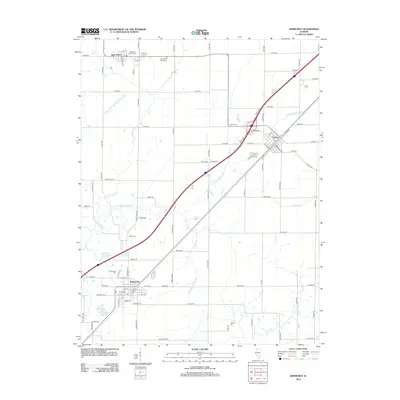
2012 Map of Kinmundy
USGS Topo · Published 2012About this map
Kinmundy and its surrounding prairie landscapes are defined by the convergence of agricultural transport routes and the winding tributaries of the Kaskaskia River system. This 2012 study details the precise layout of Saint Peter to the northwest and Farina to the northeast, connected by a network of county roads and rail lines. Local history is deeply embedded in the land through a series of burial grounds, including the Old Saint Peter Cem and New Saint Peter Cem, as well as the more isolated Cockell Cem to the south. The drainage patterns of Lone Grove Br, Schneider Springs Br, and the East Fork Kaskaskia River illustrate the natural hydrology that has dictated the placement of homesteads and townships for generations. Notable water features like Kinmundy Lake offer a focal point for the community near the southern edge of the quadrangle.
Find a feature on this map
92 named features on this map. Tap any name to fly to it.
Don’t see what you’re looking for? This feature index may not catch every label — zoom into the map to look around manually.
Map Details
Editions of this 2012 Kinmundy Map
This is the sole edition of this map. No revisions or reprints were ever made.
Other maps of this area

1934 · Salem
USGS Topo · 1:62,500

1938 · Salem
USGS Topo · 1:62,500

1945 · Kinmundy
USGS Topo · 1:62,500

1947 · Kinmundy
USGS Topo · 1:62,500

1952 · Xenia
USGS Topo · 1:62,500

1956 · Edgewood
USGS Topo · 1:62,500

1958 · Belleville
USGS Topo · 1:250,000

1962 · Belleville
USGS Topo · 1:250,000
1965 · Salem North
USGS Topo · 1:24,000
1965 · Omega
USGS Topo · 1:24,000