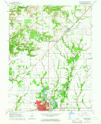
1965 Map of Salem North
USGS Topo · Published 1966About this map
The city of Salem sits at a critical rail crossroads in the mid-1960s, where the Illinois Central and Chicago and Eastern Illinois railroads converge. This urban center serves as a hub for the surrounding township lands, featuring the Warmouth St Armory and the Salem Leckrone Airport to the north. The landscape is defined by the drainage of Crooked Creek and the Salem Reservoir, which provide essential water resources for the growing community. Beyond the city limits, the rural countryside is dotted with family-named landmarks and historical community centers like Givens Chapel and Green Ridge Ch. Local genealogy is well-represented through numerous burial sites including Martin Cem, Alma Cem, and Hardin Cem, while the small settlements of Alma and Tonti anchor the smaller railroad stops and road junctions north of the county seat.
Find a feature on this map
46 named features on this map. Tap any name to fly to it.
Don’t see what you’re looking for? This feature index may not catch every label — zoom into the map to look around manually.
Map Details
Editions of this 1965 Salem North Map
2 editions found
Other maps of this area

1914 · Centralia
USGS Topo · 1:62,500

1934 · Salem
USGS Topo · 1:62,500

1935 · Centralia
USGS Topo · 1:62,500

1938 · Salem
USGS Topo · 1:62,500

1945 · Kinmundy
USGS Topo · 1:62,500

1945 · Vandalia
USGS Topo · 1:62,500

1947 · Vandalia
USGS Topo · 1:62,500

1947 · Kinmundy
USGS Topo · 1:62,500

1958 · Belleville
USGS Topo · 1:250,000

1962 · Belleville
USGS Topo · 1:250,000