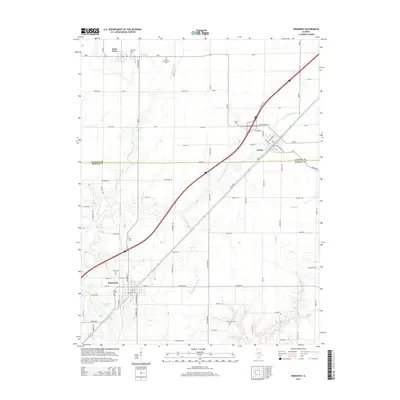
2015 Map of Kinmundy
USGS Topo · Published 2015About this map
The Kinmundy and Farina corridor highlights a landscape defined by the intersection of southern Illinois agriculture and significant water systems. Spanning the boundary of Fayette Co and Marion Co, this area is drained by the E Fork Kaskaskia River and its tributaries, including Lone Grove Br and Lost Fork. The survey provides critical spatial data for genealogists, documenting several distinct burial grounds such as the Old Saint Peter Cem, New Saint Peter Cem, and Cockrell Cem. The southern portion of the sheet features Kinmundy Lake and the Schneider Springs Br, illustrating the local hydrological network that supports the surrounding townships. The grid of rural routes, including Armstrong Rd and Jahraus Rd, connects these long-established settlements across the undulating terrain of the Illinois prairie.
Find a feature on this map
77 named features on this map. Tap any name to fly to it.
Don’t see what you’re looking for? This feature index may not catch every label — zoom into the map to look around manually.
Map Details
Editions of this 2015 Kinmundy Map
This is the sole edition of this map. No revisions or reprints were ever made.
Other maps of this area

1934 · Salem
USGS Topo · 1:62,500

1938 · Salem
USGS Topo · 1:62,500

1945 · Kinmundy
USGS Topo · 1:62,500

1947 · Kinmundy
USGS Topo · 1:62,500

1952 · Xenia
USGS Topo · 1:62,500

1956 · Edgewood
USGS Topo · 1:62,500

1958 · Belleville
USGS Topo · 1:250,000

1962 · Belleville
USGS Topo · 1:250,000
1965 · Salem North
USGS Topo · 1:24,000
1965 · Omega
USGS Topo · 1:24,000