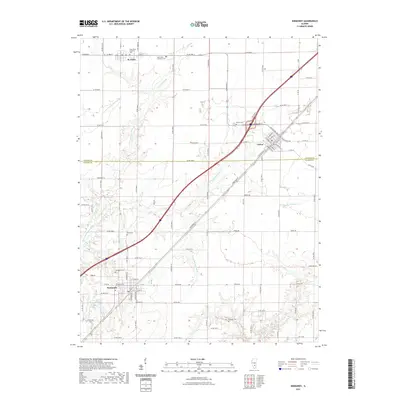
2021 Map of Kinmundy
USGS Topo · Published 2021About this map
Kinmundy and Farina anchor this south-central Illinois landscape where the southern edge of the Grand Prairie meets the rolling drainage of the Kaskaskia river system. This 2021 edition provides a contemporary view of the region's agricultural layout, straddling the line between Fayette and Marion counties. In the north, the village of St. Peter sits near the Saint Peter Lutheran Ch and its associated Saint Peter Lutheran Cem, while the town of Farina shows its developed street grid including W Washington St and Chestnut St. The terrain is defined by the winding paths of the N Fork E Fork Kaskaskia River and Schneider Springs Br, which carve through the farmland. Local history is preserved in several rural burial grounds such as Gray Cem, Evergreen Cem, and Cockrell Cem. To the southwest, Kinmundy Lake provides a significant water feature near the city limits.
Find a feature on this map
85 named features on this map. Tap any name to fly to it.
Don’t see what you’re looking for? This feature index may not catch every label — zoom into the map to look around manually.
Map Details
Editions of this 2021 Kinmundy Map
This is the sole edition of this map. No revisions or reprints were ever made.
Other maps of this area

1934 · Salem
USGS Topo · 1:62,500

1938 · Salem
USGS Topo · 1:62,500

1945 · Kinmundy
USGS Topo · 1:62,500

1947 · Kinmundy
USGS Topo · 1:62,500

1952 · Xenia
USGS Topo · 1:62,500

1956 · Edgewood
USGS Topo · 1:62,500

1958 · Belleville
USGS Topo · 1:250,000

1962 · Belleville
USGS Topo · 1:250,000
1965 · Salem North
USGS Topo · 1:24,000
1965 · Omega
USGS Topo · 1:24,000