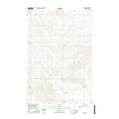
2017 Map of Kinsey NW
USGS Topo · Published 2017About this map
Caprock Coulee defines the drainage patterns of this Custer County landscape, where complex topographical contours reveal the intricate erosion of the Montana plains. This 2017 survey by the U.S. Geological Survey documents a region primarily shaped by seasonal watercourses and public land survey divisions. The intermittent flows of Custer Cr and Harris Cr cut through the terrain, illustrating the natural water-management system of the high plains before they join larger basins. These ephemeral streams, including Saugus Cr and Cabin Cr, serve as the primary landmarks in an area dominated by open range and section-line boundaries. The map provides a precise look at the transition between various township and range blocks, such as t12n r48e and t11n r48e, which have governed land use in this part of the state for over a century.
Find a feature on this map
11 named features on this map. Tap any name to fly to it.
Don’t see what you’re looking for? This feature index may not catch every label — zoom into the map to look around manually.
Map Details
Editions of this 2017 Kinsey NW Map
This is the sole edition of this map. No revisions or reprints were ever made.
Other maps of this area

1953 · Miles City
USGS Topo · 1:250,000

1957 · Miles City
USGS Topo · 1:250,000

1958 · Miles City
USGS Topo · 1:250,000

1965 · Morehouse Creek
USGS Topo · 1:24,000

1969 · Noble Reservoir
USGS Topo · 1:24,000

1969 · Kinsey NE
USGS Topo · 1:24,000
1969 · Coal Bank Spring
USGS Topo · 1:24,000

1969 · Kinsey
USGS Topo · 1:24,000
1969 · Shirley
USGS Topo · 1:24,000
1969 · Kinsey NW
USGS Topo · 1:24,000