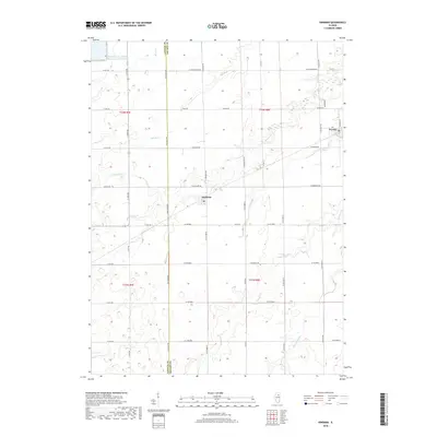
2018 Map of Kinsman
USGS Topo · Published 2018About this map
Kinsman and Verona anchor this corner of the Illinois prairie, where the agricultural grid meets industrial infrastructure and natural waterways. The landscape is defined by the LaSalle Co Grundy Co line and a dense network of country roads including W Mine Rd and W Burkhart Rd. A significant portion of the northwest corner is occupied by the LaSalle County Nuclear Station Cooling Pond, a massive artificial reservoir that stands in contrast to the meandering natural drainage of Waupecan Cr and Thunder Cr. These streams, along with Johnny Run and Murray Slough, cut through the terrain, indicating the local hydrology that has shaped farming and settlement patterns. The map detail reflects a modern rural environment where historic town centers remain small, isolated by large-scale land uses like the cooling pond and expansive township sections.
Find a feature on this map
45 named features on this map. Tap any name to fly to it.
Don’t see what you’re looking for? This feature index may not catch every label — zoom into the map to look around manually.
Map Details
Editions of this 2018 Kinsman Map
This is the sole edition of this map. No revisions or reprints were ever made.
Other maps of this area

1892 · Morris
USGS Topo · 1:62,500

1892 · Marseilles
USGS Topo · 1:62,500

1916 · Marseilles
USGS Topo · 1:62,500

1918 · Morris
USGS Topo · 1:62,500

1940 · Marseilles
USGS Topo · 1:62,500

1948 · Dwight
USGS Topo · 1:62,500

1950 · Dwight
USGS Topo · 1:62,500

1953 · Morris
USGS Topo · 1:24,000
1954 · Morris
USGS Topo · 1:62,500

1958 · Odell
USGS Topo · 1:62,500