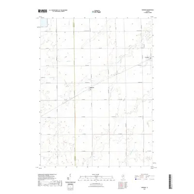
2021 Map of Kinsman
USGS Topo · Published 2021About this map
Verona and Kinsman anchor this agricultural landscape on the LaSalle Co Grundy Co line. The terrain is defined by a dense network of drainage, where Waupecan Creek and its tributaries, such as Thunder Creek and Bills Run, wind through the grid of section-line roads. Near the western edge, the Hegland Cemetery serves as a quiet landmark for local genealogists, while the small settlement of Kinsman centers around its local Post Office. The names of the roads, such as W Mine Rd, hint at the industrial history of the region, even as the primary character remaines tied to the rural prairie and the winding course of Murray Slough in the southeast corner.
Find a feature on this map
42 named features on this map. Tap any name to fly to it.
Don’t see what you’re looking for? This feature index may not catch every label — zoom into the map to look around manually.
Map Details
Editions of this 2021 Kinsman Map
This is the sole edition of this map. No revisions or reprints were ever made.
Other maps of this area

1892 · Morris
USGS Topo · 1:62,500

1892 · Marseilles
USGS Topo · 1:62,500

1916 · Marseilles
USGS Topo · 1:62,500

1918 · Morris
USGS Topo · 1:62,500

1940 · Marseilles
USGS Topo · 1:62,500

1948 · Dwight
USGS Topo · 1:62,500

1950 · Dwight
USGS Topo · 1:62,500

1953 · Morris
USGS Topo · 1:24,000
1954 · Morris
USGS Topo · 1:62,500

1958 · Odell
USGS Topo · 1:62,500