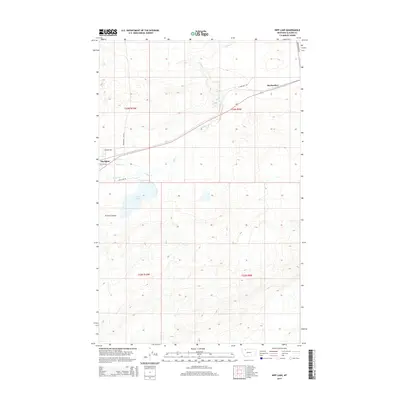
2014 Map of Kipp Lake
USGS Topo · Published 2014About this map
Blackfoot and Meriwether anchor this 2014 survey of the Montana high plains, where the landscape is defined by the sweeping drainages of Willow Cr and Flatiron Cr. The terrain transitions from the low-lying basin of Kipp Lake in the north to the rising elevations of Kittson Coulee in the south. Transportation patterns reflect a mix of modern transit and older local paths, with Us-2 cutting a diagonal path through the township sections. A network of named rural routes, such as Bearskin Rd, La Breches Rd, and the Blackfoot Cutoff, suggests a long-standing ranching and agricultural infrastructure. The survey provides a clear view of land divisions across townships T33N and T32N, documenting the persistence of small settlements along the rail-aligned corridor of northern Glacier County.
Find a feature on this map
17 named features on this map. Tap any name to fly to it.
Don’t see what you’re looking for? This feature index may not catch every label — zoom into the map to look around manually.
Map Details
Editions of this 2014 Kipp Lake Map
This is the sole edition of this map. No revisions or reprints were ever made.
Other maps of this area

1911 · Blackfoot
USGS Topo · 1:125,000

1914 · Heart Butte
USGS Topo · 1:125,000

1918 · Heart Butte
USGS Topo · 1:125,000

1960 · Cut Bank
USGS Topo · 1:250,000

1963 · Cut Bank
USGS Topo · 1:250,000

1964 · Cut Bank
USGS Topo · 1:250,000
1968 · Piegan
USGS Topo · 1:24,000

1968 · Rimrock Butte
USGS Topo · 1:24,000

1968 · White Man Coulee
USGS Topo · 1:24,000
1968 · Magee Ranch
USGS Topo · 1:24,000